Can AI Prevent A Collision At Sea?
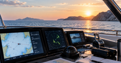
A boat is approaching from starboard, another is moving quickly from behind and several smaller targets are scattered across the navigation display. Radar shows where objects are, AIS identifies some of the vessels and the chartplotter calculates how closely their courses may intersect. The skipper still has to decide which target matters, whether the other vessel has seen them and what manoeuvre will create enough passing distance without introducing a new risk.
Marine electronics manufacturers are now asking software to do more of that interpretation. Their latest systems can compare radar returns, AIS information, chart data and the boat’s own movement, identify the encounters most likely to become dangerous and, in some cases, suggest a route around them. Collision avoidance is moving from a collection of alarms towards a form of navigational assistance that resembles the driver-support systems already familiar from cars.
For recreational boaters, the promise is appealing. Busy waterways contain more information than an inexperienced operator can comfortably process, particularly at night, in fog or when several vessels are moving at different speeds. A system that can direct attention towards the most urgent risk could prevent an uncertain situation from developing into an emergency.
The important word is assistance. Marine AI may see patterns that a person misses, but it does not understand the water in the way a competent skipper does. It cannot yet be treated as a digital captain, and a convincing route shown on a screen is not proof that the manoeuvre is safe.
What the boat can already see
Modern navigation systems build their picture of the surrounding water from several sources, each with its own strengths and omissions. GPS establishes the boat’s position. Electronic charts show coastlines, depths, navigational marks and known hazards. Radar detects objects by sending out radio waves and measuring the signal reflected from land, vessels, weather cells and other targets. AIS receives transmitted information from participating vessels, including their position, speed and direction of travel.
When these systems are connected through a multifunction display, the skipper can view much of the information on one screen. A cargo ship may appear as an AIS symbol overlaid on the chart, while radar confirms that a physical target is present in the same location. The system can calculate the closest point of approach and estimate how soon the two vessels will reach it.
Those calculations have supported collision avoidance for years. Their usefulness depends on the operator recognising what the numbers mean, configuring the alarms appropriately and understanding that the projected encounter will change whenever either vessel alters speed or course.
AI-assisted systems aim to reduce some of that workload. Instead of treating every target as equally significant, the software can examine the movement around the boat, distinguish the encounters most likely to become dangerous and present them in a clearer order of priority. Some systems now create visual risk indicators around approaching targets, while others can generate a proposed avoidance route using information collected from radar and electronic charts.
The result is less like a simple alarm and more like a second opinion at the helm.
Why crowded water is difficult to interpret
Collision avoidance appears straightforward when two boats meet in open water. The picture becomes less obvious at the entrance to a harbour, in a narrow channel or near a popular anchorage where commercial ships, ferries, fishing vessels, sailing yachts and small motorboats may all be moving differently.
A fast vessel that is currently some distance away may present a greater risk than a nearby boat travelling slowly on a parallel course. A target that appears harmless can become important after changing direction. An alarm based on a fixed distance may sound repeatedly in busy water, encouraging the operator to reduce its sensitivity or stop paying attention.
Better software can help by considering the developing encounter rather than distance alone. It can examine direction, speed and the projected passing point, then highlight the vessels requiring closer observation. Doppler radar can also show whether a target is moving towards or away from the boat, making the display easier to interpret at a glance.
This support is particularly useful for charter guests operating an unfamiliar vessel. Different boats accelerate, turn and stop in different ways, while the layout and settings of the electronics may take time to understand. A clear warning that identifies a developing collision risk can give the operator more time to look outside, assess the situation and make a deliberate adjustment.
That extra time matters. Many poor decisions at sea are not caused by complete ignorance of another vessel’s presence, but by recognising the danger too late and responding with an abrupt or ambiguous manoeuvre.
AI can recommend a route, but it cannot negotiate one
A suggested avoidance route may appear to resolve the encounter neatly. The software knows the boat’s position, recognises nearby targets and plots a course that preserves a safer distance. What it cannot know with certainty is how everyone else will behave.
The other skipper may alter course at the same moment. A fishing vessel may be constrained by its gear. A sailing yacht may tack. A small craft without AIS may enter the proposed route. Local traffic patterns may make a technically possible manoeuvre unwise, even when the chart shows enough water.
Collision regulations are intended to make encounters predictable by assigning responsibilities according to the vessels’ relative positions, activities and limitations. Technology can help identify the geometry of the situation, but the person in command still has to understand which rules apply and whether the suggested action would be clear to the other vessel.
A small course adjustment may not be visible enough to communicate intent. A dramatic turn may solve one encounter while creating another. Slowing down may be safer than changing direction, particularly near a harbour or in restricted visibility. These decisions depend on context that is difficult to reduce to a single recommended line on a screen.
The skipper must therefore treat the proposed route as information to evaluate rather than an instruction to follow.
AIS does not show every boat
AIS has transformed situational awareness by allowing vessels to share their identity, position, course and speed. It is especially valuable when a ship is hidden by darkness, rain or another obstruction, and it helps recreational boaters understand the movement of commercial traffic long before the vessels pass.
Its coverage is incomplete. Not every recreational boat carries an AIS transmitter, and some smaller vessels may only receive information without broadcasting their own position. Kayaks, paddleboards, swimmers, floating debris and many fixed objects will not appear as AIS targets. Transmitted data may also be delayed, inaccurate or entered incorrectly.
Radar can detect objects that do not transmit, although its performance depends on the equipment, installation, settings, weather and the target itself. A large metal vessel creates a stronger return than a small wooden boat or a person in the water. Waves, rain and reflections from land can clutter the display, while an operator who has not learned to adjust the radar may miss a weak but important target.
Cameras equipped with optical and thermal sensors add another layer. AI can analyse the image, identify certain objects and warn the crew when something appears ahead. Thermal imaging is valuable at night, while optical systems can help distinguish objects that produce an uncertain radar return.
Even a combined system retains blind spots. Salt, spray, glare, darkness and poor positioning can reduce camera performance. Sensors may disagree, and the absence of an alert cannot establish that the water is clear.
The lookout remains outside the screen
A multifunction display can become so informative that it draws the skipper’s attention away from the environment it is meant to explain. Charts, radar returns, AIS symbols, depth readings and alerts compete for space, creating a detailed electronic version of the water while the real situation continues to develop outside.
A proper lookout cannot be replaced by watching a screen. People aboard should continue scanning the horizon, checking blind areas and listening for engines, horns or changes in the surrounding traffic. On a sailing boat, sails and deck structures can conceal an approaching vessel. On a motorboat, passengers, roof supports and the bow itself may obstruct parts of the view.
The display is most useful when it directs attention back towards a specific area. An alert should prompt the operator to locate the target visually, compare its apparent movement with the electronic information and decide whether the risk is developing as predicted.
Repeated false or irrelevant alerts can undermine that process. Operators may begin acknowledging warnings automatically or disabling them because the system appears too sensitive. Collision zones and alarm times should therefore suit the boat, its speed and the waters in which it is operating. Settings that work offshore may create constant noise inside a busy marina.
A renter should not change unfamiliar safety settings casually. The owner or captain can explain how the system has been configured and which alarms are expected during the trip.
Poor visibility is where assistance earns its place
Fog removes many of the visual cues used to judge another vessel’s distance and direction. At night, lights can be difficult to interpret against the shore, while rain may reduce visibility at the same time that it adds clutter to the radar display.
These conditions give integrated navigation systems their strongest case. Radar can reveal targets before they become visible, AIS can identify transmitting vessels and software can calculate whether the courses are converging. An AI-supported display may then separate the urgent encounter from surrounding traffic and make the developing risk easier to understand.
None of this makes poor visibility routine for an inexperienced boater. Speed should reflect the conditions, additional lookout may be needed and the crew must be prepared to navigate without relying on visual landmarks. Sound signals and the rules governing restricted visibility still apply.
Technology improves the information available; it does not turn an unsuitable trip into a suitable one. Charter guests who are not confident using radar or navigating at night should adjust the itinerary, return earlier or book a professional captain rather than expecting the equipment to compensate for limited experience.
The systems themselves can fail
Navigation equipment depends on electricity, data connections and correctly installed sensors. A damaged cable, software fault or low-voltage problem can remove several functions at once. GPS interference or inaccurate chart data can place the boat somewhere other than where the display suggests, while a radar that has not been tested before departure may provide little help when the weather deteriorates.
Automation adds another form of dependency. The more effectively a system handles routine interpretation, the easier it becomes for the operator to lose the underlying skill. A boater accustomed to following highlighted targets may struggle when the feature is unavailable or when the display produces conflicting information.
Competent navigation therefore requires some separation between systems. The operator should know how to verify position, read the chart, interpret basic radar and assess another vessel’s movement visually. Relevant charts and route information should remain available when mobile coverage disappears, and essential electronics should be checked before leaving the dock.
AI can reduce cognitive workload, but it should not remove the crew’s ability to function without it.
What renters should ask before departure
A listing may describe a boat as having radar, AIS or an advanced chartplotter without explaining how the equipment is configured. Renters planning to operate the vessel themselves should ask which systems are fitted, whether the boat transmits AIS or only receives it and whether the displays include collision alarms or route-assistance features.
The handover should cover more than switching the equipment on. The renter needs to know how targets are displayed, what an alarm sounds like, how to acknowledge it and which settings should not be changed. The owner should also explain any limitations they have noticed, such as radar shadows created by the vessel’s structure or equipment that performs poorly at certain speeds.
A short demonstration near the marina can be more useful than a long technical explanation at the dock. Seeing how another vessel appears on the chart and radar helps the renter connect the symbols with the physical traffic outside.
Anyone who does not understand the system should say so. Modern electronics can make a boat easier to operate, but unfamiliar equipment can create false confidence or unnecessary confusion. Booking a captain remains the better option when the planned route involves congested approaches, night navigation or conditions beyond the renter’s experience.
Responsibility will remain human for some time
Commercial shipping is moving towards remotely operated and increasingly autonomous vessels, and regulators have begun defining how those ships should be designed, certified and supervised. Even there, the emerging framework continues to emphasise human oversight and the master’s overall responsibility.
Recreational boating is much further from handing control to an autonomous system. The boats are diverse, the operating environments are unpredictable and the surrounding traffic includes vessels carrying very different levels of equipment. A family motorboat, fishing skiff and commercial ferry may share the same water without sharing the same ability to detect one another.
AI can still make a meaningful contribution. It can organise complex information, identify a dangerous pattern earlier and offer an avoidance option while there is still time to consider it. In poor visibility or crowded water, that support may prevent a minor uncertainty from becoming a close encounter.
It cannot guarantee that the target has been detected, that the data is correct or that another skipper will behave as expected. The safest operator will use the system without transferring judgement to it: look outside, understand the encounter, make an early and visible decision, then continue checking whether the situation is developing as planned. AI may help prevent a collision at sea. The responsibility for preventing it remains at the helm.